Skip to content
April 27:The Sinking of the SS Sultana161yr ago

How the US Military Tracks 29,000 Objects in Space and Decides Which Ones Are Threats

Alex Carter · · 10 min read
Save
Share:
GEODSS electro-optical telescope tracking objects in deep space at night
Alex Carter
Alex Carter

Modern Warfare & Defense Technology Contributor

Alex Carter writes about modern warfare, emerging military technology, and how doctrine adapts to new tools. His work focuses on what changes in practice -- command, control, targeting, and risk -- when systems like drones and autonomous platforms become routine.

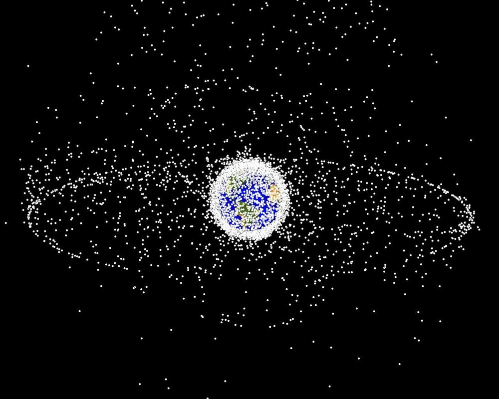
Twenty-nine thousand objects orbit Earth. The U.S. military tracks every single one. Some of them are active satellites providing communications, navigation, and intelligence. Some are dead spacecraft tumbling through the void. Some are fragments of rockets launched decades ago. And some of them are weapons, satellites maneuvered into position by adversary nations for purposes that the Pentagon monitors but doesn't publicly discuss.

The Space Surveillance Network, operated by the U.S. Space Force, maintains a catalog of every trackable object in orbit. This catalog is updated continuously by a global network of radars, telescopes, and the most sensitive search radar ever built, Space Fence, a system on Kwajalein Atoll in the Marshall Islands that can detect objects as small as 10 centimeters at orbital speeds exceeding 17,000 miles per hour.

Space domain awareness, the military's term for knowing what's up there and what it's doing, has become one of the most critical missions in modern defense. The world's militaries depend on satellites for everything from GPS-guided weapons to secure communications to missile warning. Whoever controls space doesn't just have an advantage; they can deny their opponents the ability to fight effectively on the ground.

What's Actually Up There

Of the 29,000-plus tracked objects in orbit, only about 7,000 are active satellites. The rest is debris, spent rocket stages, dead satellites, fragments from collisions and deliberate destructions, even tools dropped by astronauts during spacewalks. A fleck of paint traveling at orbital velocity carries the kinetic energy of a bullet. A 10-centimeter fragment hits with the force of a hand grenade.

NASA visualization of orbital debris around Earth showing the density of tracked objects
A NASA visualization of orbital debris around Earth. Each dot represents a tracked object. The density of debris in low Earth orbit has increased dramatically since the 2007 Chinese ASAT test created over 3,000 trackable fragments.

The debris problem is getting worse. In 2007, China tested an anti-satellite weapon by destroying one of its own defunct weather satellites, Fengyun-1C, at an altitude of 865 kilometers. The test created more than 3,000 trackable debris fragments, the single largest debris-producing event in space history. As of 2026, hundreds of those fragments remain in orbit, each one a potential collision hazard.

Russia conducted a similar test in November 2021, destroying its own Cosmos 1408 satellite and generating approximately 1,500 trackable fragments. The debris cloud threatened the International Space Station, forcing the crew to shelter in their return capsules. The test demonstrated both Russia's ASAT capability and its willingness to create debris that endangered everyone in orbit, including its own cosmonauts.

Then there's the commercial explosion. SpaceX's Starlink constellation alone accounts for over 6,000 satellites in low Earth orbit, with plans for up to 42,000. Amazon's Project Kuiper, OneWeb, and other commercial mega-constellations are adding thousands more. Each one must be tracked. Each one creates conjunction risks, potential collisions, that must be assessed and communicated.

Space Fence: The World's Most Sensitive Radar

The crown jewel of the Space Surveillance Network is Space Fence, an S-band ground-based radar on Kwajalein Atoll in the Republic of the Marshall Islands. Declared operationally capable in March 2020, Space Fence replaced the Air Force Space Surveillance System, a VHF radar "fence" that had been operating since 1961.

Space Fence radar facility model showing the S-band phased array system
A model of the Space Fence radar facility on Kwajalein Atoll. The S-band phased array radar can detect objects as small as 10 centimeters in low Earth orbit and track approximately 200,000 objects daily.

The difference between the old system and Space Fence is a matter of orders of magnitude. The legacy fence could track objects about the size of a basketball. Space Fence can detect objects the size of a softball, roughly 10 centimeters in diameter, at orbital velocities. This sensitivity matters because the debris population grows exponentially as you look at smaller objects. For every trackable fragment, there are estimated to be 10 to 100 smaller pieces that current sensors can't see but that still carry enough energy to destroy a satellite.

Space Fence operates as an "uncued" sensor, meaning it doesn't need to be pointed at a known object to detect it. The radar creates a detection barrier that objects pass through as they orbit, automatically cataloging anything above a minimum size threshold. The system can make approximately 1.5 million observations per day, roughly ten times the capacity of the network it replaced. This allows it to detect new objects that weren't previously cataloged, including fragments from collisions or breakups that haven't been publicly reported.

GEODSS: Watching from the Ground

For objects in deep space, geosynchronous orbit at 36,000 kilometers altitude, radar becomes impractical. At that distance, even powerful radars can't generate enough return signal to track small objects. Instead, the Space Force uses the Ground-based Electro-Optical Deep Space Surveillance system, or GEODSS.

GEODSS electro-optical telescope at Socorro, New Mexico, tracking objects in deep space
A GEODSS (Ground-based Electro-Optical Deep Space Surveillance) telescope. These systems use reflected sunlight to detect and track objects in geosynchronous orbit, 36,000 kilometers above Earth.

GEODSS telescopes are located at three sites around the world: Socorro, New Mexico; Maui, Hawaii; and Diego Garcia in the Indian Ocean. Each site operates multiple telescopes that use reflected sunlight to detect objects in high orbit. The telescopes image stars as points of light; anything moving against the stellar background is an orbital object. By measuring its position over time, operators can determine its orbit and add it to the catalog.

Geosynchronous orbit is strategically critical because that's where most military communications satellites, missile warning satellites, and intelligence-gathering satellites operate. A threatening satellite in GEO could approach a high-value asset, a missile warning satellite, for example, and potentially disable or destroy it. GEODSS provides the ability to detect such maneuvers and alert commanders.

Conjunction Assessment: Predicting Collisions

With 29,000 tracked objects in orbit and more being added every month, the probability of collisions is no longer theoretical. The 18th Space Defense Squadron at Vandenberg Space Force Base performs conjunction assessment, analyzing orbital data to predict when two objects will pass close enough to each other that a collision is possible.

The squadron screens roughly 50,000 conjunction events per day. Most are at distances large enough to pose no risk. But several times per week, a conjunction is close enough to warrant notification to a satellite operator. And several times per year, the risk is high enough that a satellite must maneuver to avoid a collision.

Combined Space Operations Center staff monitoring space surveillance workstations
Operators at the Combined Space Operations Center monitor space surveillance data. The center screens approximately 50,000 conjunction events per day to identify potential collision risks.

The International Space Station maneuvers to avoid debris multiple times per year. Each avoidance maneuver costs fuel, a finite resource that limits the station's operational lifetime. Commercial operators like SpaceX have automated collision-avoidance systems for their Starlink satellites, but the sheer number of satellites in the constellation creates a coordination challenge that didn't exist a decade ago.

The conjunction assessment mission also serves as an early warning system for hostile activity. If a satellite that has been dormant suddenly begins maneuvering, the Space Surveillance Network detects the change. If a satellite approaches another satellite in an unusual pattern, analysts flag it for further investigation. The line between space debris tracking and space intelligence is thin, and the same sensors serve both missions.

The Threat: Weapons in Orbit

China and Russia have both developed and tested anti-satellite weapons. China's 2007 kinetic-kill ASAT test destroyed a satellite from the ground. Russia's Nudol missile system has been tested multiple times against targets in space. Both countries have deployed satellites capable of maneuvering close to other nations' satellites, a capability that could be used for inspection, intelligence gathering, or interference.

Russia's Cosmos 2542 satellite, launched in 2019, deployed a sub-satellite that maneuvered close to a classified U.S. reconnaissance satellite. The maneuver was detected by the Space Surveillance Network, and the U.S. Space Command publicly acknowledged the encounter, calling it "unusual and disturbing." The incident demonstrated that the ability to track objects in orbit is also the ability to detect hostile actions before they escalate.

China has launched multiple satellites with robotic arms capable of grappling other objects in orbit. While these could be used for legitimate purposes like removing debris, they also represent an anti-satellite capability. The Space Surveillance Network monitors these satellites' orbits continuously, watching for any maneuver that brings them close to allied assets.

The Growing Challenge

The Space Surveillance Network was designed in an era when a few hundred active satellites shared orbit with a manageable amount of debris. Today's environment, with mega-constellations adding thousands of satellites and adversary nations conducting ASAT tests that generate thousands of debris fragments, is straining the system's capacity.

Space Fence dramatically increased the network's sensitivity and throughput, but the problem is growing faster than the solutions. The number of trackable objects has roughly doubled in the past decade. The number of conjunction events requiring assessment has grown proportionally. And the strategic importance of space, for both military operations and civilian life, means that any failure in space domain awareness could have consequences far beyond orbit.

The 29,000 objects currently in the catalog are only the ones large enough to track with existing sensors. Below the detection threshold, an estimated 100 million fragments smaller than one centimeter orbit Earth. Each one carries enough energy at orbital velocity to puncture a satellite's skin or damage a solar panel. The space environment is becoming congested, contested, and increasingly hostile, and the U.S. military's ability to track what's up there is the first line of defense for everyone who depends on satellites, which in 2026 is essentially everyone.

Share this article

Share:

Recommended

Ace of The Skies: Can You Identify These Military Aircraft Throughout The Years?
Test Yourself

Ace of The Skies: Can You Identify These Military Aircraft Throughout The Years?

Can you identify these aircraft?

Take the Quiz

Get Military News & History in Your Inbox

Join thousands of readers receiving our weekly digest of military technology, history, and analysis.

Test Your Knowledge